

Interview with Paolo Santi, Research Director at IIT-CNR who collaborates with the Senseable City Lab (MIT) of Boston
This interview starts from the Institute of Informatics and Telematics in Italy and arrives on the other side of the ocean. This is because Paolo Santi, Research Director of the Algorithms and Computational Mathematics research unit of IIT, has lived in the United States since 2013, where he leads the MIT/Fraunhofer Ambient Mobility initiative at the Senseable city lab, part of the Massachusetts Institute of Technology (MIT).
Santi deals with smart cities. In particular, he takes on the challenge of the application of digital methods and technologies in cities. “We work on a wide range of issues, from mobility to the intelligent use of people’s devices,” he says.
The mathematics of taxis
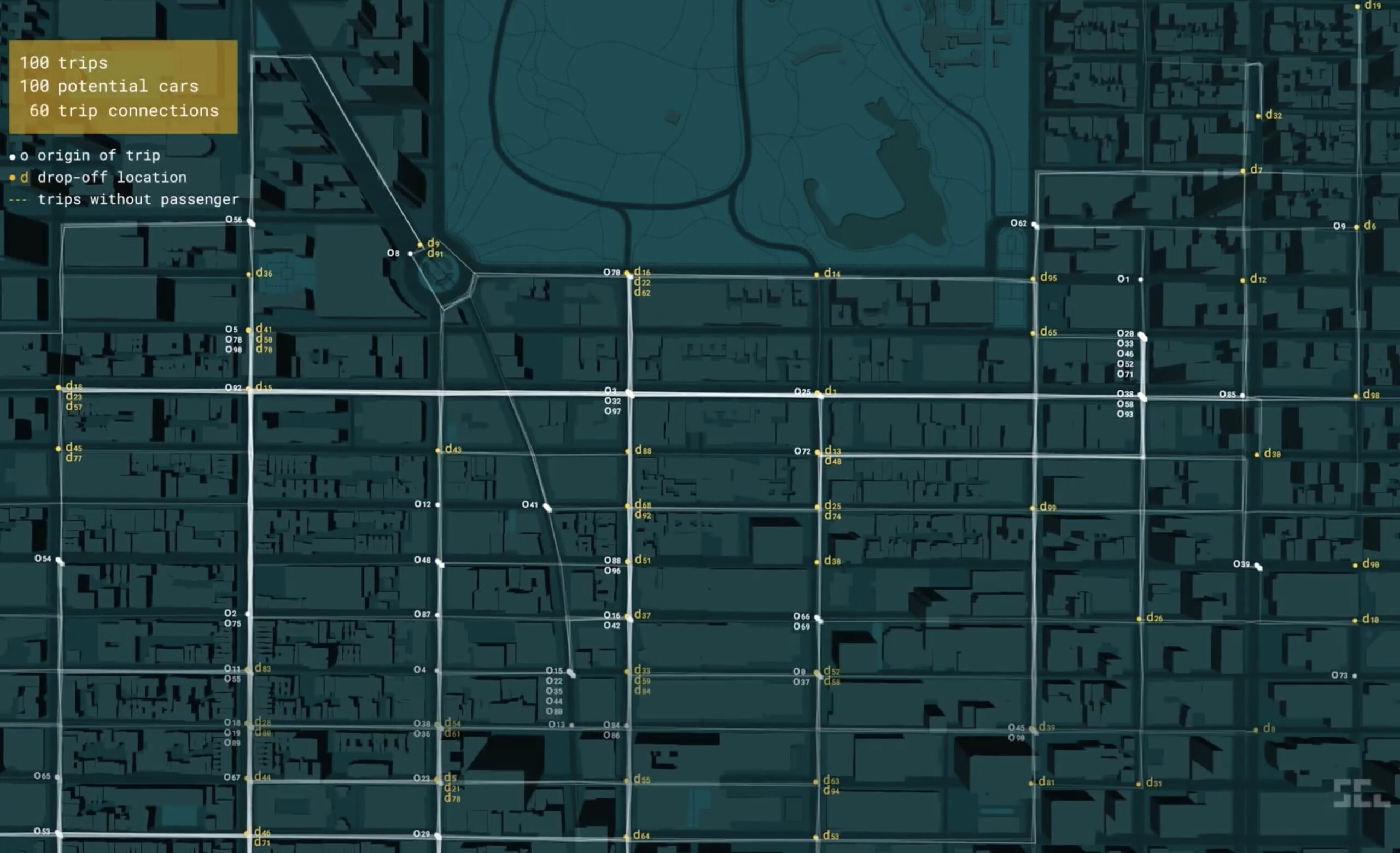
All Santi’s studies stem from mathematical problems, but often they then translate into applications in real situations. “Like the optimization of travel between home and work”, he explains. People generally have similar timetables and destinations, which is why computer scientists have thought of proposing solutions to save a few journeys thanks to shared mobility. “We used the same line of reasoning on New York taxis, starting from the real data made available by the New York Taxi and Limousine Commission. In the dense urban reality of the Big Apple, taxis make about half a million trips every day. We wondered how many of these could be shared, in order to save kilometers. It’s a complex optimization problem, and in practice we have to study mathematical combinations”.
The research has produced publications (including Nature) and patents, as well as highlighting that even an iconic phenomenon, such as taxi traffic in New York, can be made smarter thanks to technology. And it’s not completely over, as the same team is now studying the parking issue. “In an ideal situation, each and every taxi would never need to park, because after saying bye to one client the driver could pick up another straightaway”, reflects Santi.
But this almost never happens because the way we move is not balanced. So, while waiting for the next customer, the taxi driver has two solutions, park or move again. “If I move, I leave one more seat free, but I also increase the traffic. Finding a balance is a great challenge, we are studying to try to better define this compromise”.
The issue is called the minimum fleet problem and represents a fascinating challenge, since if you optimize routes and stops, and if you are able to pick up more people sharing the same route, you can reduce the number of vehicles and consequently also the traffic in general. Certainly not something of little relevance in a town like New York.
Around town
But mobility is not just about cars and parking. “We worked on about 200,000 pedestrian routes in Boston to understand the strategies that are put in place to get from one point to another in a city.” Thanks to the large amount of data made available by an app, scientists have realized that we don’t necessarily choose the shortest route, nor the one suggested by services such as Google Maps. The deviation from the minimum route is small if the route is short, whilst the change of course is greater in the case of longer routes, demonstrating that we are not too good at calculating the most appropriate direction to choose.
Furthermore, the choices are asymmetrical , that is the outward and return journeys are different. “Theories on the navigation of people in complex environments such as cities have already existed for some time. But until recently it had not been possible to demonstrate them on a large scale – only on the occasion of virtual reality experiments, with individuals invited to move around the interior of rooms or following very limited routes”, he continues.
How’s the bridge?
Another issue on which Santi works is the so-called urban sensing. The technique involves using devices that are already present in cities (such as the smartphones of its inhabitants) to detect important information. “An interesting example in this regard is the study we are conducting on the health of bridges, measured through smartphone accelerometers”. The project starts from the idea of extracting acceleration data via an app.
Thanks to GPS, the app understands when you are crossing a bridge and activates automatically to collect information on acceleration, process it and discover the natural frequencies of the bridge. “When stressed, the bridge vibrates according to certain frequencies, which vary depending on whether the structure is entirely intact or not”. The study of frequencies can reveal a problem before the first cracks visible to the human eye appear.
The problem, in practice, is obviously much more complex than that. Among the various aspects, it must be considered that the data recorded by the phones are often dirty because they are affected by the bumpy road, the traffic conditions, but also simply by the point where the smartphone is positioned inside the car. “In the first studies we put the phone on the dashboard, with good results. We saw that if it is held in the hand the results are less accurate”.
Among the bridges studied by Santi, there is the famous Golden Gate of San Francisco. “We merged the data made available by Uber with that collected by our researchers, who went back and forth across the bridge to collect the most accurate information possible”, he recalls.
The next step involves a study of Italian bridges, in collaboration with ANAS (Italian freeways construction and maintenance).
(photo credits: Senseable city lab)